PhotoFusion™
PhotoFusion™ merges satellite images and marine charts to display essential data together uniquely.
What is PhotoFusion™?
PhotoFusion™ combines satellite photos and marine charts, offering agile navigation and hyper-realistic visuals for an immersive experience.
PhotoFusion™ intelligently combines satellite imagery and electronic marine charts, presenting essential information simultaneously.
This unique technology enables smooth navigation through maps, allowing users to zoom in and out with video game-like fluidity. Its hyper-realistic visuals and exceptional zoom effect create an immersive experience for exploring marine charts.
FURUNO TECHNOLOGY
Product Manager
at Furuno
"PhotoFusion™ allows mariners to navigate with a visual clarity that was previously unimaginable, offering a seamless transition between the real-world view and charted information. The result is a chartplotter experience that not only enhances situational awareness but also boosts confidence in navigation, making it an indispensable tool for both professional and recreational mariners."
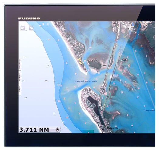
Integrating Satellite Imagery with Chart Data
Land areas (zero depth) are completely opaque, displayed as satellite photos on the chart. As the depth increases, the satellite image is merged with the chart data to provide you with added detail on seabed areas in shallow water, without losing vital chart information. In deeper water, where the satellite photos have no detail to offer, the chart is displayed without alteration.
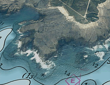
Image 1
On land, photographs are opaque to clearly showcase structures, ports, landmarks, coastlines, and rocks.
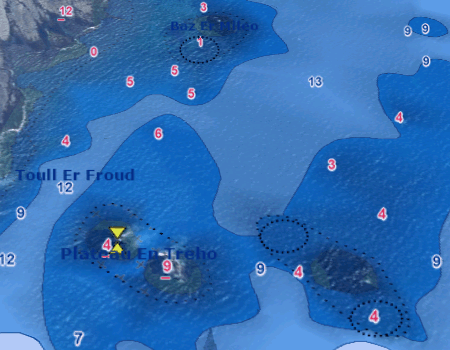
Image 2
In contrast, at sea, as the depth increases, the photographs gradually become transparent, leaving only the charts visible.
Chartplotter - Seamless Navigation Solutions for Every Maritime Sector
Furuno chartplotters are renowned for their user-friendly interface, ensuring seamless navigation for all maritime sectors. Their high-performance capabilities deliver precise and real-time data, enhancing safety and efficiency on the water. Built with reliability in mind, these chartplotters withstand harsh marine environments, making them an indispensable tool for commercial, recreational, and professional mariners alike, ensuring smooth sailing every time.
Learning the Ropes - How to Turn on Chart Satellite Photography (Satellite PhotoFusion)
D=2.2(√H1 + √H2)
D: Radar line-of-sight (NM)
H1: Altitude at which the Radar is installed (m)
H2:Altitude of the object reverberating the signal (m)
Products employing this radar technology
These radars were developed to guarantee situational awareness as they reliably and intuitively track dangerous targets.
Products employing this chartplotter technology
These chartplotters provide an unparalleled level of realism and accuracy.
ACCESORIES
Contact one of our departments to solve your problem


1815
€120
VAT Included (20%)

1815
€120
VAT Included (20%)

1815
€120
VAT Included (20%)

1815
€120
VAT Included (20%)

1815
€120
VAT Included (20%)

1815
€120
VAT Included (20%)
RADAR
Our radars deliver accurate images and reliability in all environments, combining superior performance with durability against harsh conditions.
SONAR
Our sonar technologies offer unparalleled accuracy and sustainability, ensuring optimal performance and eco-friendly practices for all fishing vessels.
FISH FINDER
Furuno's fish finder technologies have revolutionized fishing, offering unparalleled accuracy and reliability since their inception.
AUTOPILOT
Furuno's autopilot technologies enhance navigation safety and precision through advanced algorithms, real-time adjustments, and user-friendly interfaces.
CHARTPLOTTER
Our chartplotter technologies enhance maritime safety and simplify navigation by providing real-time data, precise positioning, and the best marine charts.
USER INTERFACE
User interface technologies simplify marine instrument operation, enhancing navigation efficiency and safety with intuitive, user-friendly controls.