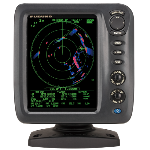
Skip to the main content.
Markets We Serve

Learn how our solutions meet the unique needs of various industries worldwide.

Advanced Technologies

Dive into the future with our state-of-the-art technologies leading the industry.

Stay Informed

Get the latest updates, insights, and resources to keep you ahead of the curve.

Risk Visualizer™


Risk Visualizer™ reduces collision risk by predicting and highlighting potential collision areas using advanced algorithms.


What is Risk Visualizer™?


Risk Visualizer™ is a radar technology that displays potential collision zones using surrounding vessel positions and movements for quick situational awareness.

Logo_Risk_Visualizer

In areas of heavy maritime traffic, such as entrances and exits of ports, vessels must constantly remain vigilant to avoid collisions with nearby ships.


The Furuno Risk Visualizer™ is a cutting-edge technology that helps minimize collision risks by highlighting potential collision zones with color-coded alerts.


This system utilizes a sophisticated algorithm developed from extensive analysis of real maneuver and navigation data, contributed by operators and navigators, to deliver highly accurate predictions.

Risk-Visualizer-graphic

Enhanced risk detection for safer navigation


In contrast to CPA/TCPA alarms, which only show the hazards on the ship's present trajectory, Risk Visualizer™ evaluates all the surrounding objects.

Senior Engineer

at Furuno

"Our Risk Visualizer™ technology is pivotal in mitigating collisions in busy waters, providing mariners with advanced situational awareness and real-time decision-making capabilities."

Radar Time Zero Tech Detail

Radar echoes displayed on the map


To safeguard fragile ecosystems and combat illegal fishing, unauthorized anchoring, or other threats to marine 
protected areas.

TimeZero V2 Radar tech detail

Real time video camera monitoring integrated into the satellite view


Essential to prevent accidents and ensure safe berthing and efficient transportation of passengers and goods.

TimeZero V2 Radar tech detail

Real time video camera monitoring integrated into the satellite view


Essential to prevent accidents and ensure safe berthing and efficient transportation of passengers and goods.

Radar Time Zero Tech Detail

Radar echoes displayed on the map


To safeguard fragile ecosystems and combat illegal fishing, unauthorized anchoring, or other threats to marine protected areas.

Radar - High - Definition Digital Vision For Your Boat, Ensuring the safety of your voyage


Discover the latest in maritime safety and comfort with Furuno's advanced radar technology. Wheter you're navigating through calm waters or facing challenging conditions, Furuno's radars are designed to ensure your journey is secure. Equip your vessel with a radard that provides critical visibility and protection against potential hazards. Explore the innovative technologies that make Furuno radars a trusted choice for seafarers worldwide.

Furuno-devices blue-radar

Line of sight of a Radar


Radar waves propagate along Earth's surface, but due to diffraction effect, these waves propagate in a slightly curved manner. The degree of diffraction is determined by many factors including atmosphere density. In general, the diffraction curve allows the wave to go beyond the line-of-sight by about 6%


Radar waves propagate along Earth's surface, but due to diffraction effect, these waves propagate in a slightly curved manner. The degree of diffraction is determined by many factors including atmosphere density. In general, the diffraction curve allows the wave to go beyond the line-of-sight by about 6%

Understanding Risk Visualizer™ in Furuno radars


Products employing this radar technology


These radars were developed to reduce the risk of collision in extremely busy waters.

See more

Line of sight of a Radar


Radar waves propagate along Earth's surface, but due to diffraction effect, these waves propagate in a slightly curved manner. The degree of diffraction is determined by many factors including atmosphere density. In general, the diffraction curve allows the wave to go beyond the line-of-sight by about 6%

D=2.2(√H1 + √H2)

D: Radar line-of-sight (NM)

H1: Altitude at which the Radar is installed (m)

H2:Altitude of the object reverberating the signal (m)

RADAR PRODUCTS

Contact one of our departments to solve your problem

ACCESORIES

Contact one of our departments to solve your problem