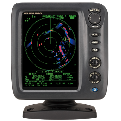
Advanced Relative Trails
Advanced Relative Trails remove stationary trails during turns, displaying only moving targets for clearer navigation.
What is Advanced Relative Trails?
Furuno's Advanced Relative Trails technology eliminates trails when turning and displays only moving targets, leaving stationary ones unmarked.

Advanced Relative Trails is a sophisticated radar technology tailored to enhance maritime navigation by providing detailed visual trails of moving targets relative to the vessel's own movement.
Thanks to the advanced relative trail and the enhanced visibility it offers by eliminating unnecessary trails, it is feasible to prevent trail overlap and differentiate a stationary sea mark (which has no trail due to its fixed position) from a nearby moving ship (which leaves a trail).
FURUNO TECHNOLOGY
How does Advanced Relative Trails work?
Comparison of trail display when the ship goes straight to the ocean
/img_true_et01_en.gif?width=600&height=532&name=img_true_et01_en.gif)
Senior Engineer
at Furuno
"With Furuno's Advanced Relative Trails technology, mariners gain an enhanced understanding of moving targets in real-time, allowing for precise navigation decisions. The clear visualization of target movement without unnecessary trails ensures safety and efficiency on the water."

Relative Echo Trails
Trail based on own ship

Advanced Relative Trail
Trail based on own ship

Real time video camera monitoring integrated into the satellite view
Essential to prevent accidents and ensure safe berthing and efficient transportation of passengers and goods.

Radar echoes displayed on the map
To safeguard fragile ecosystems and combat illegal fishing, unauthorized anchoring, or other threats to marine protected areas.
Radar - High - Definition Digital Vision For Your Boat, Ensuring the safety of your voyage
Discover the latest in maritime safety and comfort with Furuno's advanced radar technology. Wheter you're navigating through calm waters or facing challenging conditions, Furuno's radars are designed to ensure your journey is secure. Equip your vessel with a radard that provides critical visibility and protection against potential hazards. Explore the innovative technologies that make Furuno radars a trusted choice for seafarers worldwide.

Conventional relative trails & Recurrent Issues
The relative trail is a method that is especially beneficial for assessing collision risks by depicting the movement of other vessels in relation to the trajectory and speed of one's own ship.
Initially, the relative trail appeared even when the ship was turning or moving, affecting visibility until the trail was reset.
To address this, many manufacturers designed the relative trail feature to avoid displaying trails caused by the relative movement of other vessels during the ship's maneuvers.
Enhanced Visibility of Relative Trails in Coastal Areas
The Furuno Advanced Relative Trail technology removes trails during turns and displays only the trails of moving targets, leaving stationary objects unmarked (Land erase).
With the Advanced relative Trail's improved visibility by eliminating unnecessary trails, users can prevent trail overlap and easily differentiate between a stationary sea marker (no trail due to being stationary) and a nearby cruising ship (trail).
Products employing this radar technology
These radars were developed to guarantee situational awareness as they delete unnecessary trails thus enhancing the visualization of relative moving targets.


RADAR
Our radars deliver accurate images and reliability in all environments, combining superior performance with durability against harsh conditions.
SONAR
Our sonar technologies offer unparalleled accuracy and sustainability, ensuring optimal performance and eco-friendly practices for all fishing vessels.
FISH FINDER
Furuno's fish finder technologies have revolutionized fishing, offering unparalleled accuracy and reliability since their inception.
AUTOPILOT
Furuno's autopilot technologies enhance navigation safety and precision through advanced algorithms, real-time adjustments, and user-friendly interfaces.
CHARTPLOTTER
Our chartplotter technologies enhance maritime safety and simplify navigation by providing real-time data, precise positioning, and the best marine charts.
USER INTERFACE
User interface technologies simplify marine instrument operation, enhancing navigation efficiency and safety with intuitive, user-friendly controls.
Line of sight of a Radar
Radar waves propagate along Earth's surface, but due to diffraction effect, these waves propagate in a slightly curved manner. The degree of diffraction is determined by many factors including atmosphere density. In general, the diffraction curve allows the wave to go beyond the line-of-sight by about 6%
D=2.2(√H1 + √H2)
D: Radar line-of-sight (NM)
H1: Altitude at which the Radar is installed (m)
H2:Altitude of the object reverberating the signal (m)
RADAR PRODUCTS
Contact one of our departments to solve your problem
ACCESORIES
Contact one of our departments to solve your problem


1815
€120
VAT Included (20%)

1815
€120
VAT Included (20%)

1815
€120
VAT Included (20%)

1815
€120
VAT Included (20%)

1815
€120
VAT Included (20%)

1815
€120
VAT Included (20%)